


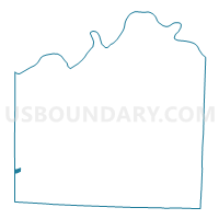
KC WD22 PCT2206, Jackson County, Missouri
About
Outline

Summary
| Unique Area Identifier | 608178 |
| Name | KC WD22 PCT2206 |
| County | Jackson County |
| State | Missouri |
| Area (square miles) | 0.34 |
| Land Area (square miles) | 0.33 |
| Water Area (square miles) | 0.00 |
| % of Land Area | 98.81 |
| % of Water Area | 1.19 |
| Latitude of the Internal Point | 38.91124270 |
| Longtitude of the Internal Point | -94.59946830 |
Maps


Graphs
Select a template below for downloading or customizing gragh for KC WD22 PCT2206, Jackson County, Missouri


Neighbors
Neighoring Voting District (by Name) Neighboring Voting District on the Map
- KC WD22 PCT2205, Jackson County, MO
- KC WD22 PCT2207, Jackson County, MO
- KC WD22 PCT2208, Jackson County, MO
- KC WD22 PCT2209, Jackson County, MO
- Leawood 2-04 Voting District, Johnson County, KS
- Leawood 2-05 Voting District, Johnson County, KS
- Leawood 3-01 Voting District, Johnson County, KS
Top 10 Neighboring County Subdivision (by Population) Neighboring County Subdivision on the Map
Top 10 Neighboring Place (by Population) Neighboring Place on the Map
Top 10 Neighboring Unified School District (by Population) Neighboring Unified School District on the Map
Top 10 Neighboring State Legislative District Lower Chamber (by Population) Neighboring State Legislative District Lower Chamber on the Map
Top 10 Neighboring State Legislative District Upper Chamber (by Population) Neighboring State Legislative District Upper Chamber on the Map
Top 10 Neighboring 111th Congressional District (by Population) Neighboring 111th Congressional District on the Map
Top 10 Neighboring Census Tract (by Population) Neighboring Census Tract on the Map
- Census Tract 134.08, Jackson County, MO (5,592)
- Census Tract 533.01, Johnson County, KS (5,170)
- Census Tract 101.05, Jackson County, MO (3,384)
- Census Tract 173, Jackson County, MO (3,281)
- Census Tract 134.07, Jackson County, MO (2,576)